Kasha Katuwe Tent Rocks and Slot Canyon
This hike gives you a chance to see the unique geologic formation
known as tent rocks. If you do this hike, you also go through a
slot canyon and up onto the mesa, leading to great views of the
Sangre de Cristo and Jemez mountains.
|  |
Hike data:
Maps:
Getting to the trailhead:
|
Exit I-25 at the NM 22 exit (Cochiti Lake), and head northwest. 0.75 mi
after you cross the Rio Grande, turn left (southwest) on NM 22
toward Cochiti Pueblo. Go 1.7 miles and turn right on Tribal Route 92
(connects to Forest Service Road 266). The turn is easy to see, because
of the large water tank painted like a drum.
The road is (or turns to) dirt, and you go 4.8 miles (but you see
the monument entrance sign after only 0.5 mile). The parking area
and trailhead are on the right.
|
|
The hike:
 |
Heading out from the trailhead, the wide, sandy trail forks almost
immediately. We took the canyon trail first, and returned through
the tent rocks and cave loop.
Our friend Michael Wester is the person in the photo looking at the
trailhead information sign.
|
We hiked past this unique ponderosa long before this area was a national
monument. You go past it as you head uphill toward the cliff base.
A little past the Y-branched ponderosa you meet the tent rocks and
cave loop again (GPS TRNMY1).
|  |
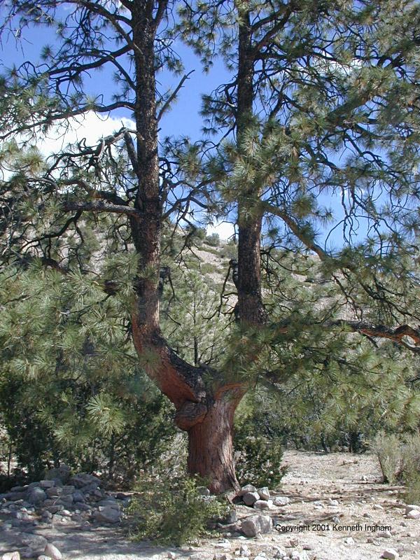
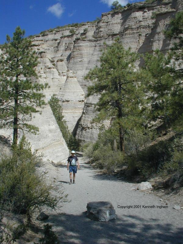
 | Just past TRNMY1 is the canyon entrance. In the photo, Michael Wester
is walking out of the canyon.
|
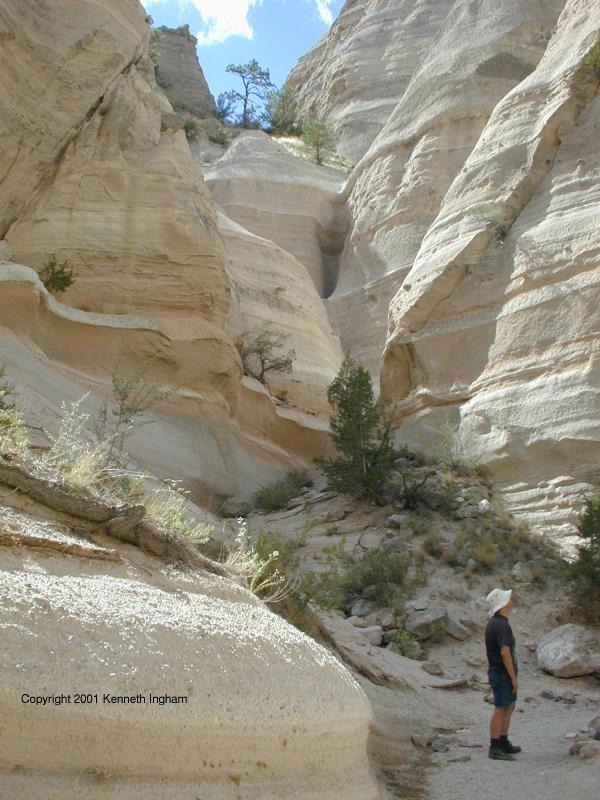
As you walk through the canyon, it varies from being just shoulder-width
to being a bit wider.
|  |
 |
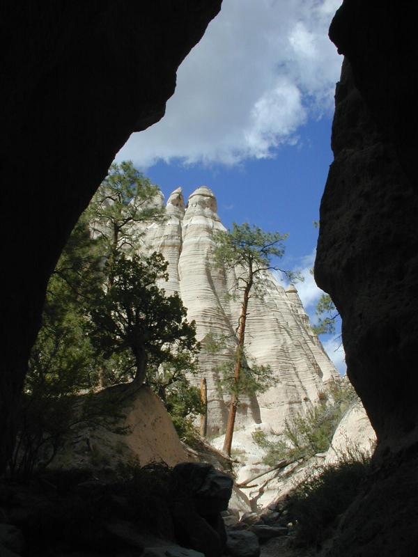
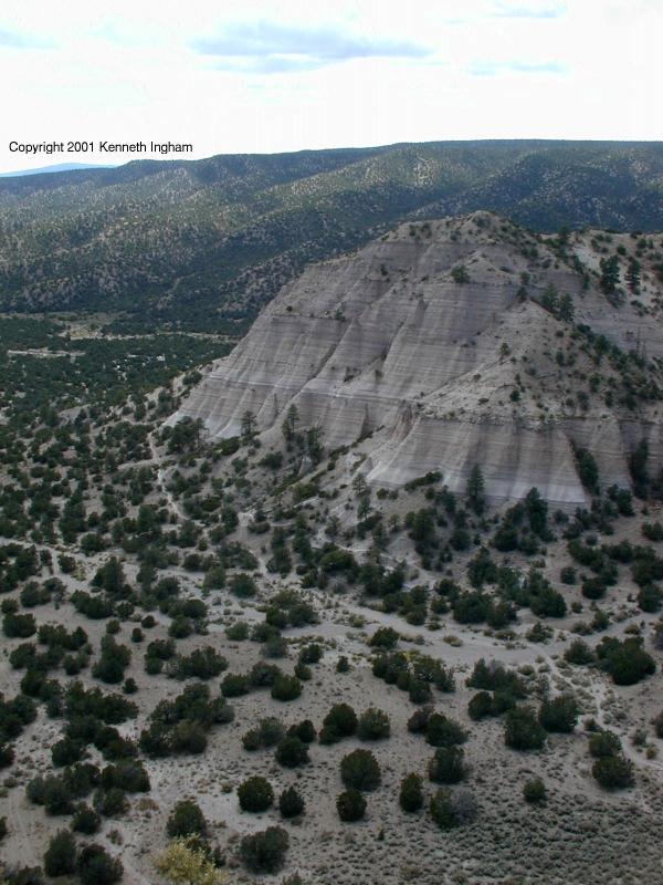
When you get out of the narrow part of the canyon, look up and to your
left to the mesa top. This is where the trail will end, and you will
be looking down on where you are now in a few minutes.
When you get to the back of the canyon, the trail heads up the side of
the canyon. You can see some of the tent rocks for which this area was
named.
|
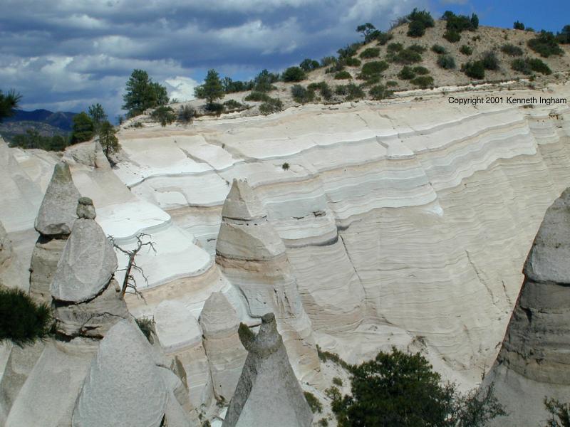
As you climb up the back of the canyon, you can look down on the tent
rocks, and see the layers.
|  |
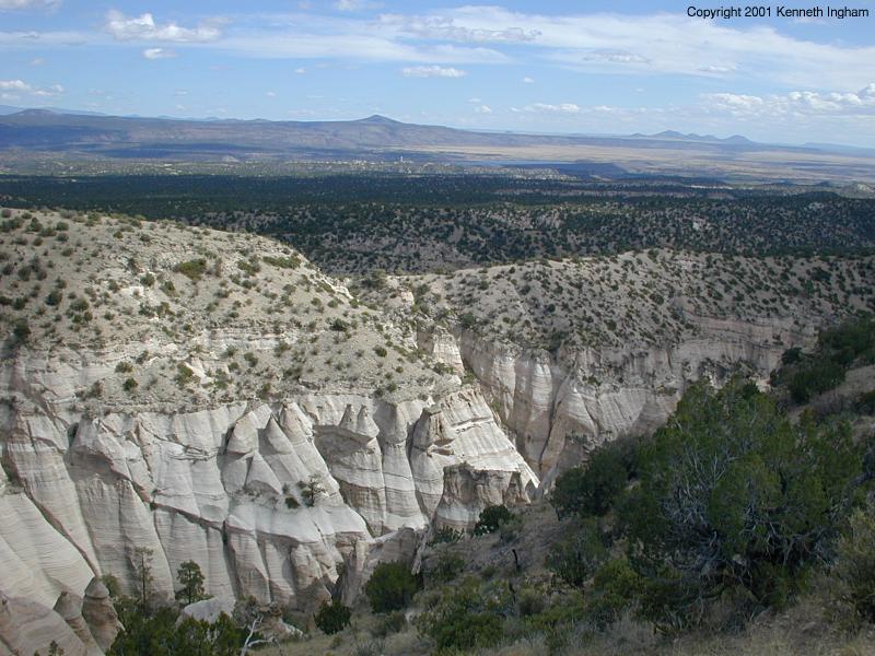
 | The views from up on the mesa top are great. Notice Cochiti Lake in the
distance.
|
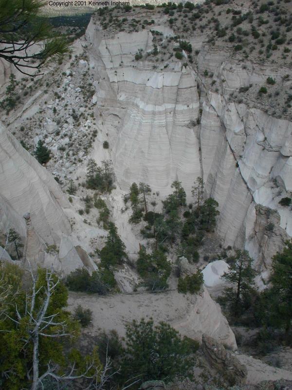
When you get to the mesa top, a trail leads down to the tip of the mesa.
Along the way, you can look down into the canyon.
|  |
 | At the end, you can see the trail that you took to get to the canyon.
|
Along the way, we saw this guy (gal? I don't know how to sex spiders :-)
hiking also. No need to be afraid. It would not bother you unless you
bothered it.
|  |
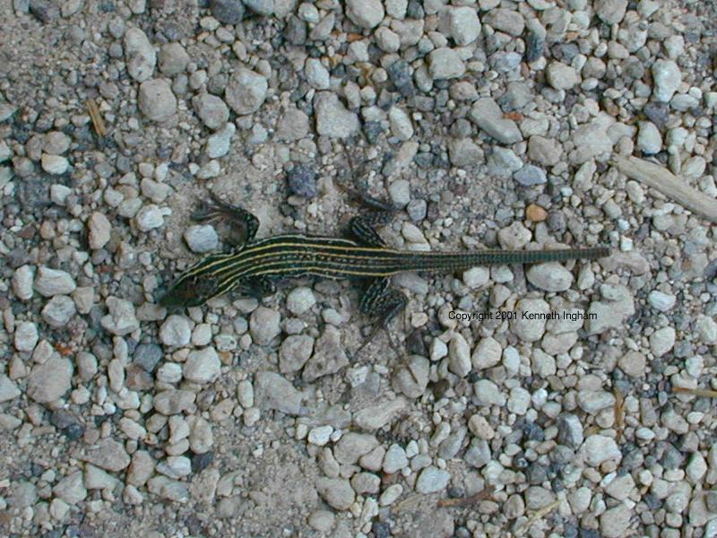
 | Another critter we shared the trail with was this lizard.
|
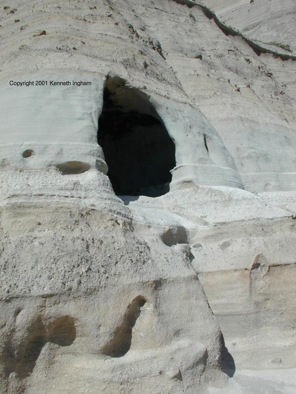
Return the way you got here to the cave loop (GPS
TRNMY1). This time, take the loop, which
goes past this shelter cave, and takes you close to some of the tent
rocks. before returning to near the trailhead.
|  |
Plants we saw along the trail:
Animals we saw along the trail:
Reader comments about this hike:
On Mon Aug 30 09:11:03 2004 Tracy from Albuquerque said:
The trailhead now has plenty of covered picnic tables and very clean
bathrooms. The whole area is fabulous!
The hike is very easy and children shouldnt have a problem leading
the way or keeping up. We had two four year old boys who hiked
both trails without any problems.
I recommend this hike to anyone and everyone who wants to get out
of the city and have fun.
On Sun Apr 24 18:09:27 2005 nilck and lynda from abq nm and SoCalif. said:
Incredible and unique!! Been around much of the USA and Canada and
never seen any formations like these. Outstanding and very easy to
do.
On Sun Jun 5 06:20:55 2005 Karen from PA said:
I hiked this two years ago; it remains a favortie of my coast to
coast hiking sites. While on the rim, a thunderstorm threatened.
We had metal trekking poles and ran til our hearts felt like bursting
to get down into the canyon. Catching our breath under a rock lodged
in the slot, we fumbled for our raingear. Looking around the corner,
I saw a flash flood rising. Again, we ran, the water rushing high
above our boots. It was awesome and frightening. When the canyon
finally widened, the water spread out, and we laughed crazily that
we had made it out ALIVE. We were soaked, covered with rock
particles--looking like cement people--blending into the bizzare
geology quite nicely!
On Mon Oct 10 08:22:12 2005 Stacey from Somewhere said:
Just Beautiful! The hike was just challenging enough. We took a picnic to the top enjoyed views of the Jemez and Sangre de Cristo mountains. The scenery made me realize why I moved to New Mexico.
On Tue Oct 11 09:17:17 2005 Jessica Simpson from Somewhere said:
It was so dirty there it wasnt even funny! the tent rocks are ok
but damn its dirty.
On Tue Oct 11 11:31:48 2005 the ExploreNM Webmaster from Albuquerque replied:
I checked with a friend who hiked this trail on September 18, 2005,
and he did not notice any cleanliness issues at that time. I will
try to get out there to check on this.
On Mon Oct 24 08:56:59 2005 kris from kristen_pedro2009yahoo.com said:
tent rocks was the best hike I've been too! because i maybe the
exercise... it was hard going to the top. but i would like to go
again with my class
On Mon Oct 24 15:07:08 2005 Marjorie Leekya from somewhere said:
i just wanted to know what the geological name for the tent rocks
is because i am having a hard time finding that in your website
Later, the webmaster replied:
I asked a geologist, and she said: "these don't have a specific
geological name. They are like hoodoos, but not quite. They are
erosional features."
On Tue Oct 25 19:10:03 2005 Michael Sattell from somewhere said:
This is one of our favorite family hikes. I will be returning this
weekend. Very easy yet beautiful trails. The tent rocks are amazing
sturctures; I noticed less eroded forms at Bandelier afterwards
(Bandelier is in the same vicinity).
On Mon Feb 13 11:36:34 2006 Anonymous from ABQ,NM said:
We have hiked this trail many times and it is a favorite, especially
with our kids. On one of the more memorable hikes we reached the
top and saw thunderclouds coming straight at us. We tried to hurry
down, but about halfway back the storm hit. There wasn't any
lightning, but there was a tremendous amount of hail. It was
incredibly cool watching "waterfalls" of hail coming down into the
canyon. By the end of the storm the entire canyon bottom was covered
with hail, and the bottoms of these "waterfalls" had a foot or more
of accumulated ice pellets. We were soaked, and a bit nervous, but
it was an incredible experience.
On Thu Jul 6 23:14:21 2006, Dave Posey from Clovis, NM said:
We did this hike on Dec. 29, 2005. It is one of our favorites. I
did find something along the hike that isn't really rare but you
don't see it very often. We found a Manzanita bush at the top of
the hike. Manzanita was used by indians for medecinal purposes,
and they also used dried leaves for smoking. Interesting.
On Tue Apr 24 23:41:09 2007 Glenn from prospect Hts., il said:
Yet another wonderful New Mexico treat to put someplace on my ever changing top ten places I would love to show someone in this most beautiful and bizarre State. Here and the Bisti always seem to remain near the top.
btw thanks to the people responsible for this site. Found it surfing around
On Thu May 17 09:52:46 2007 Stama from Tennessee said:
We hiked most of this trail on May 11, 2007. We came in late and
it so we could only do some of the hike. It was very clean. I
loved this area and highly recommend it. We were in the 4 corners
area for a week -- second trip in 10 years.
Has anyone seen the snake and wavy line petraglyphs that are near
the beginning of the canyon trail? I asked the "ranger" and he
said he never noticed them as a kid. I wondered if anyone knows
the story about these?
Thanks!
On Tue Oct 2 15:50:07 2007 Mike S from Austin, TX said:
Hiked the canyon on Monday, Oct 1, 2007 at about 1 PM with my wife / brother / sister in law. Was truly one of the most scenic and interesting places I've been. The parking / bathrooms / picnic table areas were very clean as was the trail.
Hike up and back took us about 2 hrs but that was rushing it because we had to catch a flight back home. We would have loved to have taken a LOT more time there but at least we have something to look forward to because we will be back!
On Mon Jan 21 01:53:38 2008 Bob from Kentucky said:
We will be vactioning is Santa Fe this June and might like to hike this area. We are not trained hikers and was wondering how hard this hike is? What gear is a must and what attire should we ware? How long is the hike and what will the weather be like?
Also any other destionations that might be of intreast for a family?
Thanks, Bob
On Mon Jan 21 13:01:06 2008 The Webmaster from Albuquerque, NM said:
I do not put difficulty ratings on hikes because what is difficult
for one person my be trivial for another. For this hike, you
probably only need good shoes and clothes appropriate for the weather
when you arrive. If you do not climb to the mesa top, most people
would consider this an easy hike. As for gear, you need water and
sun screen. A hat is probably a good idea as well. Details about
the hike length and times are at the top of the page.
Bob, you should use the suggestion form for
your question; I normally reply personally to questions like this.
However, since you did
not leave your email address, I cannot respond to you.
On Fri Apr 25 15:32:57 2008 C.S. from Germany said:
We had a very fast hike onto the top in May 2007. The tent rocks are really very special! We were lucky to be there all alone, so nothing disturbed the majestic silcence and the fantastic landscape around.
Great place to see again!
On Wed Apr 30 11:09:21 2008 Mark Cohen from Takoma Park, Maryland said:
We enjoyed our visit tremendously, but had an unfortunate experience at the end that we wanted to warn folks about. We only had a very short time to visit, and arrived only a few hours before the 7 PM closing time. We paid our $5 dollars, talked to the gate attendant about potential hikes, were told that the park closed at 7 PM, and to watch our time. Well, we did the whole hike and got back to our car at around 6:55, and unfortunately arrived back at the gate at about 7:05 (there is a ~4 mile dirt road to the gate). When we arrived, we found the gate locked with no way to get our car out! We called the numbers on the gate, eventually got to talk with some one, and they eventually came out to open the gate. It was a very disappointing experience for everyone involved. It was shocking to us that we were not told the "GATE CLOSES at 7 PM" by the gate attendant when we arrived, or that this fact was not displayed prominently. We meant no disrespect, and if we had simply been told what would happen, we would have definitely made it back before 7 PM. The person who came to unlock the gate was very upset... The whole interaction ruined the visit for us, but could have easily been avoided.
On Thu May 15 20:08:00 2008 Russ from El Paso, TX said:
Phenomenal! I'm constantly amazed by the beauty of the southwest. Bring a boonie cap or a good hat to cover your neck as you hike, bring water in something you can attach to your body as you climb (especially near the top), and come early to enjoy this hike. Also, if it is supposed to be windy watch out...the sand stings!
Enjoy, enjoy, enjoy!
On Sat May 24 20:33:52 2008 Penny of NC from North Carolina said:
We visited NM for the first time May 17, 2008 and ended up hiking Tent Rock, we were in TOTAL AWE, I love nature and what it has to offer, my eyes were just amazed at what we saw, it's one of those "OMG, can you belive this place" we loved it and if I ever get back to NM, I would do it again, and I found the hike moderatley easy, with some light climbs. BEST location west of the Mississippi.
On Mon Jun 2 08:08:06 2008 robin from Albuquerque said:
We (family of 3) visited on June 1st, 2008. Wow! It was even more fabulous than we had expected. The slot canyon was fun and gorgeous. We took both video and still photos and we were all amazed at the beauty. The tents are so bizaar and interesting and the view from the trail leading to the top is fantastic! Take a camera and lots of water! It was very sunny and hot when we visited. It took us 2 hours to do both trails (stopping often for photos). Creatures spotted: rabbits, squirrels, several types of lizards, roadrunner, and a large owl. Most of the hiking is easy but there are some areas in the climbing ascent to the top which may be difficult for some people. Overall it was our favorite hike we have ever done in NM.
Do get there early though, especially on weekends. We arrived at 9am and there were already 2 other cars in the parking lot. At 11am when we left, the parking lot was full and people were circling waiting for a spot. There is a $5 per car parking fee, clean restrooms, and lots of picnic tables. Very nice, well maintained trails.
On Sat Jul 12 14:48:44 2008 Alan from Halifax, Nova Scotia, Canada said:
Tent Rocks is one of the most spectacular and amazing places you'll get to see in North America. Why it's not better known than it is is a mystery to me. Anyone who's either in or anywhere remotely close to Santa Fe should really make time to go there. It will certainly be well worth the time and effort. For anyone who does any mountain hiking, the trek to the top of Tent Rocks will seem quick and easy. The grades are relatively gradual, and the total distance is short. In response to the person who claimed Tent Rocks is "dirty," I think she was misinformed about exactly where she was, because she certainly couldn't have been in Tent Rocks National Monument. It's spotless everywhere. Dirt? Does she mean the dust that's bound to lie on the trail? What does she expect? But dirty? Not a chance. Don't be misled by that ridiculous comment.
On Thu Jul 31 16:47:27 2008 Gloria from Somewhere said:
This site is most informative - thank you.
A note to your readers: If you loved the formations at Tent Rocks, and you have a travel bug, you must visit Cappadocia in Turkey. Look this up on the web and you will be amazed...and blown away in person.
On Sun Aug 24 23:51:02 2008 Anonymous from Milwaukee, WI said:
Just got back from hiking this awesome trail. Well worth every drop of sweat!
A few things have changed since the original review and other comments.
The trail head now has paved pathways and the area around the sign in the picture with the reviewer's friend is now paved.
For some reason, the people in charge there(who IS in charge anyway? It seems to be a National Monument, but it is administered by the BLM, but the guys taking the money at the gate are from Pueblo de Cochiti tribe?????) insisted that we park our full size conversion van in the huge open area for bus parking even though there were multiple full size pickups at least as long parked in the regular spaces!
The hike was beautiful. I would recommend going a little bit later in the afternoon though, as the lighting was better then. It is definitely in my top five favorite hikes in the West.
The reviewer stated a time of ~2 hours. Well, I am a photographer and like to spend some time, but it took me about 5 hours without going to the cave. I would say non-stop, I could have done it in about 1.5 hours, though.
I personally would not recommend it for taking small children as the latter part of the trail is steep with some very loose gravel. I saw a woman slip and fall on her way down, very close to the edge. Also, on the Mesa top, there are some precipitous drop offs without railings that could be very hazardous for children.
One commenter stated that they got locked in after 7 PM. Well, there is now a one-way spike strip in place, so you shouldn't have a problem exiting after 7 PM, but I would ask to be sure.
I would definitely do this hike again and recommend it to anyone.
Thanks for the writeup as I may have never gone here without having found and read it!
On Thu Oct 9 13:07:53 2008 Julie Alexander from Dallas, TX said:
This is a favorite hike for my husband & I. It was our first"official" hike after we decided to become hikers. We have only hiked it in the winter (late Dec.) and even if the weather is cold, you warm up quickly from the effort of the hike. We like to get there early, by 8AM to beat the crowds. The lighting is good at that time for photos as it would be in late afternoon, but less crowded. Last time we only passed 1 other hiker on the way up, but the way down got busy. This is truly a spectacular hike, the slot canyon being my favorite part.
On Wed Oct 29 20:13:34 2008 Karl from northern Indiana said:
Gorgeous hike on Oct 21, 2008. Saw a little over a dozen people during my 2.5 hour afternoon stroll and one tarantula. Took a ton of photos. Thank you to this site for steering me here.
I would change the driving directions to note that those coming from the north should exit US 25 at NM 16 (exit 264). This intersects with NM 22 (turn right).
On Tue Nov 4 09:51:27 2008 Rachel from Rio Rancho, NM said:
The Tint Rock are is a fav. for our family. For all of the obvious reasons. Beauty, fun, and the hike. However, I haven't read anything from anyone about one of the most fun parts of the hike. If you look along your path you will see it covered with black and greyish looking rocks. These are Apache Tears.
From Wikipedia, the free encyclopedia:
Apache tears are a kind of nodular obsidian (volcanic black glass). An Apache tear looks opaque until it is held up to light, which reveals it to be translucent. Although black is the most common color for Apache tears, they can range in color from black to red to brown.
Apache tears have rounded forms (0.5 to 5 cm). They are often found embedded in a greyish-white perlite matrix.
The name "Apache tear" comes from a legend of the Apache tribe. The stones are supposedly the tears shed by the wives and families of a band of Apache warriors who were killed by the U.S. military in retaliation for their raid on an Arizona settlement.
So, you learn something new eveyday. Next trip, look down too and you'll find a treasure of your very own. Enjoy.
Later, The Webmaster from Albuquerque, NM added:
Look and enjoy, but remember that taking the Apache tears from a
national monument is illegal. Please enjoy seeing them; then leave
them for the people who will follow you.
On Sun Nov 16 11:28:19 2008 Jocelyn from Chicago, IL said:
I am headed out to see the tent rocks in a couple of weeks, but wanted to know how difficult the hiking trail is? My mother is also coming to NM with me, but didnt know how "Easy" the easy trail is? She is 75 years and in good healthy condition but would not want to put her in a position to manuever around rocks or anything like that.
If anyone has any thoughts, that would be great.
On Sun Nov 16 11:41:09 2008 The Webmaster from Albuquerque, NM said:
"easy" is a relative term, which is why we try to avoid it on ExploreNM.com. What is easy for us might not be easy for someone less fit. What is a good workout for us might be easy for someone more fit than us.
The trail through the canyon is relatively flat with a few spots where you might have to scramble up some rocks. The climb up the hill to get to the mesa top is more challenging, because it is easier to loose your footing and go sliding back down hill.
I think that you should take your mother out to the canyon, because at least the initial part should be accessible to her.
On Tue Mar 3 20:57:47 2009 L Williamson from Albuquerque, NM said:
We hiked the Slot Canyon and Cave Loop last weekend. Great fun for the whole family, 4 kiddos and mini-Dachshund. The Slot Canyon trail was quite busy. I was impressed with the picnic and parking area. The gate attendant was well informed and helpful. The first area of the Slot Canyon trail is easily accessible. The climb to the top of the mesa may be difficult for some, but worth the views if you can make it. Glad to find the treasure so close to home! We'll be back!
On Thu May 21 09:00:19 2009 dhummel from Santa Fe, NM said:
Effective May 23, 2009, Kasha-Katuwe Tent Rocks National Monument is closed to dogs. For more information, please see the BLM NM website.
On Tue May 26 22:46:14 2009 JAC from Albuquerque, NM said:
Tent Rocks is one of the most interesting hikes in the Southwest. The parking area is nicely planned, and there are bathrooms. The trails are well hiked and the elderly or handicapped can enjoy the Cave Loop and see many of the tent rock formations without the challenge of the slot canyon, which has some very narrow areas as well as boulders to climb over. The lower part of the slot canyon is a beautiful twisted hike that kids will love as they go under a gigantic boulder lodged between the cliffs and under a fallen tree. The canyon walls keep the lower trail cool, and is a welcome relief if one hikes the upper, open trails atop the mesa in the sun.
Take pleanty of water, wear hiking shoes, not sandals or flip flops as it is easy to turn your ankle on the gravelly parts.
Do not hike into the slot if rain threatens! Like any arroyo, the canyon will fill quickly with flash floods of water draining from the canyon walls and tent rocks.
The canyon walls/tents are made of "tuff", the ash fallout from ancient volcanos which fell, hundreds of feet deep, and then compressed to form the semi-hard cliffs. You can see the "layers" in the cliff & tent sides and the slightly harder parts stay while the wind/water erodes the softer, less compressed areas. The softer areas are worn away and form holes or ridges in the cliff sides. There are Apache Tears, rounded black glass "beads" of various sizes that blew out with the ash tuff that can be found in the canyon walls. Look, toouch, but leave in the canyon.
This is a photographer's paradise with the myriad shapes of oddly formed "tents". Once at the top of the climb, you can look down on the peaked tents, with some having harder stone "caps" on their heads. The view is spectacular as you can see the Sangre de Cristos, the Sandias, and the Jemez Mountain ranges beyond the colorful mesas beyond the slot canyon. In the Spring (May), the upper cliff tops are sprinkled with yellows, oranges, whites, and yellow green wildflowers, bushes, & cacti flowers.
If you are a Senior Citizen, and you have a Federal Park Pass, you may show it and get in free. Otherwise, the $5.00 entrance fee is far worth it to see this spectacular gift of Nature.
On Sun Nov 22 19:36:40 2009 Catherine from Albuquerque, NM said:
This hike left me amazed that this beautiful place was tucked away here in New Mexico! I've lived in ABQ for about 10 years and just started hiking within the last year; this was a pleasant surprise.
The 3.5 mile hike (Slot Canyon and Cave Loop) took me about 2 hours, and I still had time to rest, chat with other hikers, and take pictures. The trail was busy and I would suggest getting as early a start as possible. I arrived about 10 am and passed 5 people on my way up, and 22 people on my way down. I was alone at the top, and the silence and the view were a huge bonus.
I was very worried that I would not be able to make the trek because I'm not physically fit, but I did it! There was only one part where I was worried because it required me to literally get on my knees to climb up a rock that was about 3 ft up with no step in between. The incline toward the end of the Slot Canyon hike had my heart pumping, but it was completely doable. Take your time and it's a breeze. Even if you're not in the best of shape, but work out on a fairly regular basis and hike some, the Slot Canyon hike is completely doable. Go for it!
The entrance fee was still $5, and the parking area was safe. The bathroom was clean, and the trails are well marked.
I did come across some travelers with problems: dying batteries, no water or snacks, not enough time, no camera, and poor clothing and shoe choices. So, make sure you bring extra batteries and you must have water. I did the hike today and the weather was perfect. No matter when you go, I still would suggest wearing jeans, a long sleeve shirt, and hiking boots. The walls through Slot Canyon are shoulder-wide at some points, grainy, and have rocks jutting out. And, of course, there are at least 8 places where you're going to have to climb up and over rocks.
Add your comments about the Kasha Katuwe Tent Rocks and Slot Canyon
hike.
Visitors since the counter started: 47492
Copyright © 1997-2009 Kenneth Ingham Consulting, LLC.
For details about the copyright, see the full
Copyright
statement.
Unhappy? Thinking of suing us? Read this disclaimer.
You can read our privacy statement.
Comments? Send them via the
suggestion form.